
Ketapang Station Relocation
TABLE OF CONTENTS
History of Banyuwangi Station
The Dutch East Indies government first constructed a railway network in the East Java region (Oosterlijnen). Through the state railway company, Staatsspoorwegen (SS), the initial line was built from Surabaya to Malang via Pasuruan. The concession for the construction of this $112\text{ km}$ line was based on the Law of April 6, 1875, Staatsblad Number 141. Four years later, on July 20, 1879, the Surabaya–Malang railway was opened to the public.
Gradually, SS extended construction westward from Surabaya to Solo, while the eastward expansion was continued toward Banyuwangi. In 1903, the construction was completed all the way to Banyuwangi.
| No | Line | Length (km) | Inauguration Date |
|---|---|---|---|
| 1 | Pasuruan–Probolinggo | 40 | May 3, 1884 |
| 2 | Probolinggo–Klakah | 34 | July 1, 1895 |
| 3 | Klakah–Jember | 62 | June 1, 1897 |
| 4 | Jember–Panarukan | 89 | October 1, 1897 |
| 5 | Kalisat–Mrawan | 30 | September 10, 1902 |
| 6 | Mrawan–Banyuwangi | 58 | February 2, 1903 |
Source: Korte Geschiedenis der Nederlandsch-Indische Spoor en Tramwegen
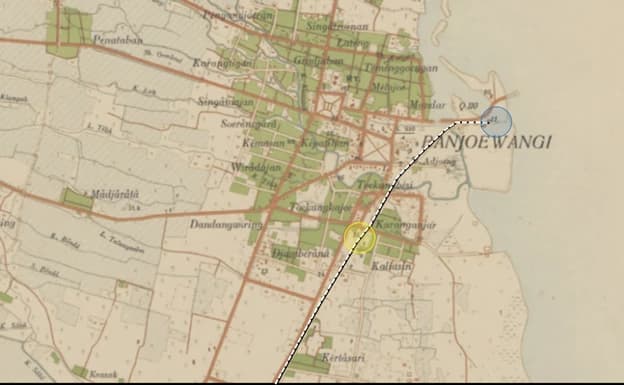
Concurrently with the inauguration of the Mrawan–Banyuwangi line on February 2, 1903, Banyuwangi Station was also opened to the public. This easternmost station of Java was integrated with the port in Banyuwangi, specifically in the Mandar area, known as Boom Port.
At that time, Boom Port served as an economic gateway and a commercial trading hub. Historically, the port—now known as the Old Banyuwangi Port—also served as a demarcation line of political hegemony between the Mataram Kingdom and Jembrana, Bali.
The Banyuwangi Station building featured an elongated design with a gable-style roof. The central section of the station was built higher than the left and right wing sides, functioning as a main hall. The central roof was decorated with a gable (gevel) and a ridge finial (noc artery). The main entrance was located in the middle of the hall, sheltered by a canopy. The facade featured numerous window openings optimized for air circulation and natural lighting.
The left side of the building was utilized for station operations, housing the ticket and baggage room, the cash storage room, the station master's office, and the telegraph room in succession. Meanwhile, the right wing was dedicated to passenger services, including the Class 1 and Class 2 waiting rooms, a canteen, the Class 3 waiting room, and a warehouse. The Class 3 passenger waiting room was located at the far end; although it shared the same roof, this specific area did not have walls.

Image 1: The location of Banyuwangi Station is marked by the yellow circle, while Boom Port is marked by the blue circle, from a 1915 map. (Source: KITLV Batavia: Topographische Inrichting, 1915)

Image 2: A group of horse-drawn carriages (dokar) waiting for passengers at Banyuwangi Station. (Source: Spoorwegstations op Java)

Image 3: The atmosphere of the Banyuwangi Station platform area, showing the far end of the station which served as an open waiting room for Class 3 passengers. (Source: Tropenmuseum TM-60052294)
Banyuwangi Station served both passenger boarding and freight logistics. A portion of the incoming goods was subsequently shipped out through Boom Port to Bali or other regions, and conversely, goods from outside the island were brought into Banyuwangi via Boom Port.
As mentioned previously, passenger waiting rooms were differentiated by class, dividing train passengers into three categories: Class 1 was reserved for Europeans; Class 2 was intended for Foreign Orientals (such as Chinese and Arab ethnicities) as well as indigenous officials; and Class 3 was for the general indigenous population.
In 1926, records show that 12 trains called at Banyuwangi Station daily, consisting of two round-trips for the Kalibaru–Banyuwangi route and four round-trips for the Kalisat–Banyuwangi route. During that same year, traveling between Kalibaru and Banyuwangi took about two and a half hours, while traveling from Kalisat to Banyuwangi took a similar amount of time.

Image 4: The Banyuwangi–Kalisat train timetable in 1926. (Source: Officieele Reisgids der Spoor en Tramwegen en Aansluitende Automobieldiensten op Java en Madoera, May 1, 1926)
The Old Banyuwangi Station handled passenger and freight transportation entering and leaving the Banyuwangi city port (now Boom Beach). Kabat connected the original line built by the Dutch with the new line constructed by the Indonesian government during the PJKA era.
The New Banyuwangi Station (Ketapang)
During the war to defend independence between 1945 and 1949, the railway became a vital instrument of struggle. In both Java and Sumatra, railway services were prioritized for military and wartime logistical needs, causing severe damage to much of the railway infrastructure.
Following the recognition of sovereignty, the Railway Department of the Republic of Indonesia (DKARI) and the Staatsspoorwegen en Verenigde Spoorweg Bedrijf (SS/VS) were merged into the Railway Department (Djawatan Kereta Api - DKA). Under DKA's management, the comprehensive rehabilitation and repair of Indonesian railways began.
Regarding station facility management, DKA determined standard provisions and transport capacity requirements. This was formalized through the Decree of the Director of DKA No. 20493/BB/54 dated March 16, 1954, which classified stations into six categories: Large Stations, Class 1 Stations, Class 2 Stations, Class 3 Stations, Class 4 Stations, and Class 5 Stations. Based on this decree, Banyuwangi Station was categorized as a Class 2 station.
In 1950, passenger volume at Banyuwangi Station reached 206,237 people. However, in 1951 and 1952, passenger numbers declined to 166,942 and 146,850 people respectively. Meanwhile, freight transport in 1950 stood at 22,887 tons, increasing to 27,397 tons in 1951, before dropping to 22,109 tons in 1952.
The decline in traffic at Banyuwangi Station mirrored the dwindling activity at Boom Port. Geographically located at a river estuary, the port suffered from heavy siltation and shallowing caused by river sediment. Maintaining the port required massive operational costs that often exceeded its generated revenue.
Furthermore, Boom Port lacked modern loading and unloading facilities. As a result, the port was deemed incapable of accommodating the growth of larger, modern motorized vessels built with higher cargo capacities. Cargo ships found it increasingly difficult to berth at the pier.
Consequently, all port operations in Banyuwangi were relocated from Boom Port to Meneng Village, adjacent to the Ketapang Ferry Terminal. This relocation took effect on January 1, 1974.
As maritime transit demands grew, it became necessary to integrate intermodal transportation, which included building a railway line directly to the new port area. The construction of this new line started from a branch at Kabat Station leading toward the Ketapang port area.
On September 7, 1985, the Kabat–Banyuwangi Baru line was officially opened alongside the commencement of operations at Banyuwangi Baru Station. The opening of this line caused the relevance of the Old Banyuwangi Station to fade rapidly. Passenger services at the Old Banyuwangi Station were redirected to the New Banyuwangi Station to streamline transit from the ferry port to the railway. Ferry services from Banyuwangi to Bali were moved from the city center to Ketapang Port, leaving the old station to handle only freight trains.
On March 31, 1988, the Old Banyuwangi Station was officially deactivated. Freight services were also transferred to Banyuwangi Baru Station to optimize distribution to Meneng Port and Tanjungwangi Port. Simultaneously, the Kabat–Old Banyuwangi line was decommissioned. The Banyuwangi Baru Station, located at km 18+500, was renamed Ketapang Station in 2019.

Image 5: The atmosphere of Ketapang Station in 2025. (Source: KAI)
DKA Ferry Transit Operations
In addition to reviving railway activities, DKA resumed maritime ferry services starting in 1950. DKA's fleet included Motor Vessels (KM) and Tugboats (KT) used to guide large ships entering and leaving ports. The ferry routes managed by DKA included Ujung–Kamal (1950), Kertapati–Palembang (1951), and Merak–Panjang (1952).
An interesting milestone was the Ketapang–Gilimanuk Project initiated by DKA in 1962. The project was executed to support the 4th Asian Games held in Jakarta, ensuring that visitors could travel to the island of Bali quickly and affordably.
DKA ensured that tourists could reach Bali seamlessly. From Jakarta, where the Asian Games took place, tourists could take an express train to Banyuwangi. Dedicated buses were stationed there to transport them to Ketapang, where they could continue their journey across the strait to Gilimanuk using DKA ferry vessels.

Image 6: Installation of the pier and bridge joints by lifting the bridge structure using tackles and cables. (Source: DKA Magazine, December 1962 Edition)
To facilitate transit from the mainland to the vessels, DKA constructed connecting linkspans. Two 20-meter bridges were fabricated at the Barata Workshop in Surabaya. DKA workers labored day and night throughout the construction process, which culminated successfully with the completion of the bridge installation by the end of June 1962.
In August 1962, the Ketapang–Gilimanuk ferry link began provisional operations before its official inauguration in March 1963. The first vessel deployed was named the K.M. Kintamani. To streamline maritime operations, DKA established a Shipping Exploitation division in September 1966, which was formally inaugurated in October 1967.
This Shipping Exploitation division operated routine ferry links for Merak–Panjang, Kamal–Ujung, and Ketapang–Gilimanuk. Meanwhile, non-scheduled routes included Tanjungpriok–Teluk Bayur and Tanjungpriok–Belawan.
The crossing traffic from Ketapang to Gilimanuk experienced exponential growth in passengers, cargo, and vehicles, as evidenced by its development from 1967 to 1969. Remarkably, freight transport recorded a 100% annual increase.
| No | Year | Passengers | Cargo (tons) | Vehicles (units) |
|---|---|---|---|---|
| 1 | 1967 | 116,238 | 16,204 | 15,130 |
| 2 | 1968 | 188,665 | 37,459 | 27,650 |
| 3 | 1969 | 206,089 | 63,622 | 32,872 |
Source: Sekilas Lintas 25 Tahun Perkeretaapian 1945-1970
Sources:
"De Opening van de Lijn Soerabaja-Pasoeoean-Malang" in Bataviaasche Handelsblad, July 29, 1879
DKA Annual Statistics 1950-1951-1952
KITLV
"Ketika Pelabuhan Banyuwangi Digusur ke Meneng" in majalahdermaga.co.id
Korte Geschiedenis der Nederlandsch-Indische Spoor en Tramwegen
DKA Magazine, December 1962 Edition
Michiel van Ballegoijen de Jong, Spoorwegstations op Java
Officieele Reisgids der Spoor en Tramwegen en Aansluitende Automobieldiensten op Java en Madoera, May 1, 1926
Sekilas Lintas 25 Tahun Perkeretaapian 1945-1970
Tropenmuseum